Home | Pioneers | Contact Us | Copyright/Disclaimer
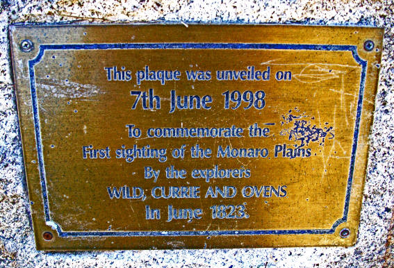
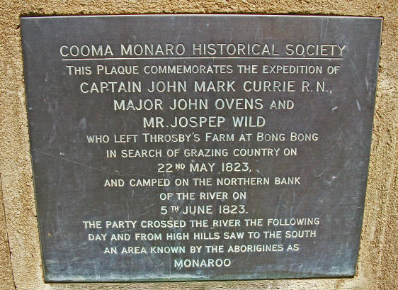
Located in the Bredbo recreation park, which is beside the Bredbo Community Hall.
Images supplied by Sandra Young
The Discovery of Manaro
"BACK TO COOMA" Felix F Mitchell 1926
The task of drawing aside the curtain that separates the past from the present, that divides yesterday from to-day, is, in its relation to Manaro, one of infinite, if not of almost insuperable difficulty. The endeavour to glimpse the lives and circumstances of those who were factors in the development of the district whilst the place was yet in its infancy, to record their arrival, to follow their struggles, to tell of their victories, to write of their failures and to
speak of their passing, is at the outset limited by an almost absolute dearth of authoritative records. Traditions, stories and memories there are that float around, only to disappear upon inquiry into their truth like the mists of night in a morning sun; accounts, vouched for with that accuracy which entitles them to become accepted history, there are practically none. It was in March 1817, that Mr. Surveyor Meehan, accompanied by Mr. Throsby, set out on an expedition which reached the Shoalhaven River. At the request of Governor Macquarie, Hamilton Hume, who afterwards achieved fame as an explorer,
though he was then only 20 years of age, accompanied them. At the Shoalhaven, Mr. Throsby, consequent upon a dispute with Mr. Meehan, left the party, and accompanied by a black boy, made his way to Port Jarvis. Meehan and Hume, however, kept on and discovered Lake George. In 1819 discoveries which had been made, combined with pastoral needs, seem to have brought about what was known as "squatting." Rumours of a wonderful elusive southern river known then as the Morumbidgee were plentiful, and when in 1821 Hume reported the discovery of Yass Plains, he must surely have been almost on its very banks.
On the 22nd May, 1823, Captain John Mark Currie, R.N., accompanied by Brigade Major Ovens, left Mr. Throsby's farm at Bong Bong for the purpose of exploring the then unknown country south of Lake George. They took with them Joseph Wild, who nearly three years earlier had discovered the Lake. Captain Currie kept with the utmost care a daily diary, completely recording all the incidents and conditions attached to and surrounding the trip, and from it the following account of their journey is taken. On the 22nd May, after crossing the Wollondilly River, they camped at a point distant 20 miles from their
starting place. The next day they made 16 miles crossing the Cookbundoon River twice. On the 24th May they camped at Mulwarry 15 miles further on, and on the 25th, having crossed the Goulburn Plains, 12 miles in extent, halted about four miles to the south-west of them, covering 20 miles during the day. On the 26th May they report leaving behind the last and most distant stock station from Sydney in this direction and reaching Lake George. This entry indicates the limits to which southerly settlement had reached and would appear to be about 35 miles north of Queanbeyan. On the 27th May they
encountered trackless and mountainous country and were then on the east bank of the Lake (about eleven miles north of the south end). On the 28th they were delayed all day by rain, but were able to proceed South-east arid then S.S.E., in all about 15 miles. On the 30th they saw an extensive plain to the southward and the Morumbidgee Mountains to the S.W., partially covered with snow. On the 31st they came to the Limestone Plains, which they crossed next day, reaching a small plain which they called Isabella's Plain, after the daughter of Governor Brisbane. They were then on the right bank of the
Morumbidgee towards its source, and along this they searched four miles unsuccessfully for a crossing place. On the 2nd June they were still unable to cross the river, and on the 3rd came upon the beginning of a long chain of down country, having crossed which they camped on the bank of a gully, which is probably identical with what is now Michelago or Ingelara Creek. On the 4th June they arrived at some very extensive downs where they met a tribe of natives, who fled at their approach, never, as they learned afterwards, having seen Europeans before. By tokens of kindness, offering them biscuits,
together with the assistance of a domesticated native of their party, they were able to make friends, though the blacks would on no account touch or approach the horses. From the natives they ascertained that the clear country before them, which was very extensive, was called Monaroo. They did not adopt the native name but called it Brisbane Downs. On the 5th June they were still on the right bank of the Morumbidgee, and from the top of a hill observed a continuation of the downs to the, south, clear of timber. They also noted an abundance of limestone and ironstone. On 6th June they write, they
crossed the Morumbidgee and saw down country for a distance of forty miles South. This was bounded on the West by a snowy range of mountains and on the East by what they thought was the coast range. Their position they gave as 149' 7' 10" East from Greenwich, whilst the northern part of the downs was calculated from Port Jackson South 391 15' West; 164 nautical miles. Checking the record of the 6th June, which the explorers give, in the light of later and more complete knowledge, both of the river and the locality in which they were it seems absolutely clear that they erred in stating
they crossed the Morumbidgee. They had been travelling on the eastern side of the river some miles from the actual bank and had for a time lost sight of it where it ran between some deep gorges. At the spot they indicate as having crossed, they show the river taking a sharp bend and then leading back almost due East. In actual fact the course of the Murrumbidgee will be found to be for some distance due South, with later a slight westerly in inclination. It would therefore be manifestly impossible for them travelling as they were South, cross at right angles to its course a river coming from due south.
Any ordinary map of the State will show that at a point not far from the intersection of the bearings given by Captain Currie 39' and 149', the river Bredbo coming from the cast and flowing almost due west, discharges into the Murrumbidgee and causes at its confluence the apparent bend the explorer's chart shows.
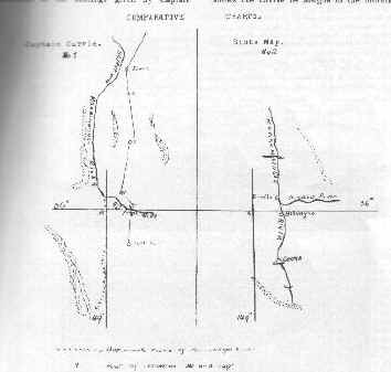
COMPARATIVE CHARTS What actually happened, it is confidently asserted, is that the intervening hills prevented Captain Currie and his companions from following the course of the Murrumbidgee, and when they came
across this river 45 feet wide," they assumed it was the one along whose bank they had been travelling for some days. If their diary, therefore, be amended so as to make the entry for 6th June, "crossed a river," instead of "crossed the Morumbidgee," the position is perfectly clear and in accordance with the description they otherwise give. After crossing the river they add that they went on for some miles almost due South. This would indicate that they crossed the Bredbo River, and having reached the neighbourhood of what afterwards became Billilingra Hill, saw the downs country they speak of. In
order to make the contention of the mistake of the explorers apparent to those who may be interested in these notes, two sketches are attached. No. I is an exact copy of that portion of the map prepared by Captain Currie, which shows the course he assigns to the Morumbidgee River and the point at which he crossed. No. 2 is a copy from a State map of the course of the same river and the junction of the Bredbo with it. The point of intersection of the bearings given and common to each is shown on each sketch. On the 7th Captain Currie and his party started on their return journey, regretting that a
shortage of provisions prevented them from exploring the downs, which they were anxious to do by reason of their interesting nature connected with the subject of sheep grazing, so essential to the staple product of the Colony. Their outward journey was 197 miles. The lowest daylight thermometer reading was 28F. on 30th May, the lowest sunset register 33* on 3rd June, and the highest noon reading, 54* on. 7th June. There are no available records indicating the steps taken to open and develop the downs country reported on by Currie and Ovens. It seems certain, however, that in the years almost directly
following upon the latter's expedition, the limits of settlement referred to by them were gradually pushed out southerly. It will be borne in mind that Captain Currie attained his southernmost point on 7th June 1823. In 1827 settlement had reached as far South as what is now known as Gegedzerick, near Berridale, some 20 miles S.W. of Cooma, for on 24th March, 1853, Mr. R. Brooks, the holder of Gejizrick Run, writing from Maneroo to Mr. G. R. Nicholls, a solicitor practising in Castlereagh Street, Sydney, complains of wrangling being existent in connection with disputed boundaries of various holdings,
and says, "One of my neighbours has been encroaching on my run for 14 or 15 years." In the same letter he adds, "I have been in possession since 1827, at which time the only animals running on the land were kangaroos and emues." Further on still he writes: "I have old servants, that brought up the stock in 1827, to prove my claim." The letter is clearly authentic, and other matters referred to therein are corroborated by existing records. There is no inconsistency in the reference to 14 or 15 years' encroachment prior to 1853 this would go back to 1838 or 1839 only. It is reasonable to believe that Mr.
Brooks, being in the vanguard, may, between 1827 and 1838, not have been troubled by neighbours. Further, Mr. Brooks' eldest son, W. H. Brooks was born at Gejizrick in 1838. It is clear that in 1834, and probably for some few years previously, settlement was in existence in the neighbourbood of Michelago, for we learn in that year that one, "Jack the Rammer," a bushranger who had been operating in the Manaro district, shot Mr. Charles Fisher Shepherd, the overseer for Mr. Caldwell, of the Michelago Sheep Station. A man named Boyd, who was associated with Jack the Rammer, upon being pursued by the
Police, was shot as he was endeavouring to escape by swimming the Snowy River. It is gathered from the available records that in 1823 Currie and Ovens reached as far as Billilingra, or in the neighbourhood of from 12 to 14 miles north of Cooma. In 1827 Mr. Brooks was located at Gegedzerick, near Berridale. In the very early thirties Wambrook Run, as can be seen from the account given of Joseph Ward, was occupied by Ward and Bowler as a cattle station. In 1834 Michelago was a recognised sheep station and Bunyan was occupied by Dr. Reid. It would seem, therefore, as though the progress of
Manaro, the acquisition of its wide spaces and their subsequent development, its history from the stages of early settlement to those others that saw the creation of a prosperous village or town, has been achieved not by those definite exploratory expeditions which were such a marked feature of the early days of colonization in other parts of the State, but by some slow moving yet irresistible process of expansion which kept on finding expression only in an extension of settlement beyond its then ever varying limits.
Manaro, as
such, originally included the whole of the southern tableland from Michelago to Gippsland and across to Kiandra. In more recent years it has generally been recognised as comprising that network of towns and villages which, with Cooma as its central point, took in Michelago, Colinton, Bredbo, Umeralla (now Chakola), Cooma, Nimmitabel, Berridale, Dalgety, Jindabyne, Adaminaby and Kiandra, with a large tract of country in between Cooma, Braidwood and Queanbeyan. Bombala and its associated towns, have not been mentioned, as they may be considered to constitute a separate area under the name of Southern
Manaro. The early history of Cooma of necessity involves the record of the places named, which were, then not settlements, but merely portions of large runs. Cooma as a town seems to have gained its name from the fact that it formed part of a run of that name held, as to 19,000 acres by William Bradley, who included in his area, but as a detached portion thereof, Mittagong or Bridgery; as to 30,000 acres by James Kirwan; as to 1,280 acres by John Lambie, and as to 5,000 acres on Cooma Creek by Walter Turner after W. Bradley. Thus in 1848, when the leases of the runs were applied for, Cooma consisted
of 55,280 acres, or about 85 square miles held by three men. When the Maneroo district had settled or dwelling in it a sufficient number of people to render it advisable for some centre to be selected where from to administer the ordinary functions of Government, a Court of Petty Sessions was constituted in 1847, and a proclamation defined the juristriction of the Bench as existing within certain boundaries given as "COOMA" In the squatting district of Menaro and embracing the County of Beresford and parts of the Counties of Wallace and Wellington; bounded on the North by the south boundary of the
County of Murray to the Murrumbidgee River at the confluence of Micaligo thence by the Murrumbidgee River upwards to the confluence of Gap Creek, thence by that creek upwards about one mile and a half by a tributary of that creek up to its source in Mount Clear; thence by the dividing range between Neece Valley Creek and the Murrumbidgee River and the dividing range between Yihac Creek and the Murrumbidgee to their confluence, thence by the Murrumbidgee upwards to the source, which rises in the range between that river and the Goodradigbee River; and thence by that range and the range dividing the
waters of the Goodradigbee and Tumut Rivers to the great dividing range to the source of the Tongara. or Jacob's River; on the South by that river to the Snowy River; by the Snowy River to the confluence of the McLaughlin River; and thence by the range dividing the waters of the Snowy and Umaralla Rivers from those of the McLaughlin River to the great dividing range to the south boundary of the County of Murray aforesaid." And it is of the lands so defined and the people who lived on them that the records in this booklet purport to treat. Throughout this Souvenir the word "Manaro" has been variously
spelt. Where extracts have been taken from official records or old documents or letters, the respective spellings therein have been adopted, otherwise the writer has preferred to adopt "Manaro." One reason for this is that in many of the native names which have been applied to localities or stations, and a number of which have been set out in the section dealing with Aboriginals, the syllable "ma" repeatedly appears.
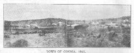 TOWN OF COOMA, 1865
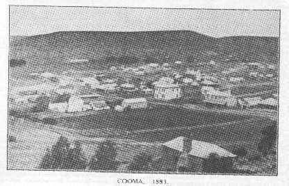 COOMA. 1883.
Extracts from: Early Days in Western Australia
Please do not be put off by the title. This book was compiled from the Letters and Journal of Lieut. H.W. Bunbury, 21st Fusiliers and edited by his son, Lieut.Col. W .St.Pierre Bunbury and WP Morrell (a professor of Antipodean History at Oxford University). Henry William Bunbury is my husband's Great Gt. Grandfather and sailed
into Sydney on the Convict Ship Susan in 1834 where, before joining his regiment who were in Van Diemen's Land, and then subsequently being posted to W.A. (where the town Bunbury is named after him) managed to attach himself as a temporary ADC to the Governor or NSW. Images supplied by
|
![]()
 Monaro
Pioneers
Monaro
Pioneers